GIS Day was organized by Esri, a leading company in the field of mapping technologies, and has been celebrated since 1999, after consumer advocate Ralph Nader suggested dedicating a day to show how geographic intelligence touches everyone. According to Esri, “a Geographic Information System (GIS) lets us visualize, question, analyze, and interpret data to understand relationships, patterns, and trends.” GIS Day celebrates these capabilities and allows users to showcase their unique GIS accomplishments. This year, Pare celebrated the “Mappiest Day of the Year” on November 15 by looking at how we are using this technology in our engineering projects.
GIS can use a variety of sources including GPS data, open source data layers, and CAD-compatible shapefiles to display a variety of data in a visually appealing way. This capability is especially important in providing a meaningful deliverable to a client. Maps and figures typically include aerial photographs of a site as the base map, which is then layered with other data such as wetland locations or other constraints in order to better understand the geographic restrictions of a project. The attributes of the geographically referenced information can be resourcefully stored, analyzed, evaluated, manipulated and displayed.
Pare’s GIS committee manages and uses data to create visualizations of project information so that it can be more easily shared and analyzed. It gives our engineers the tools needed to complete buildout projections, locus mapping, dam-breach modeling, water system modeling, site constraint analysis, and infrastructure asset management.
As part of our “Mappy Day” celebration, the GIS committee celebrated four recent projects that used GIS to better help the client.
Narragansett Bay Commission CSO Phase III Program
Pare created a GIS database containing shapefiles of select portions of the existing Narragansett Bay Commission Combined Sewer Overflow (CSO) system within the cities of Central Falls and Pawtucket. This database was generated using scanned copies of the city’s original printed drawings dating back to the mid-1800s. The digital format was then imported into a hydraulic model using record plans of the existing CSO system and aerial photograph interpretation. Georeferencing these plans allowed Pare to view the locations of the CSO system in relation to the current layout of the cities and understand flow directions and connectivity within the sewersheds. In addition, Pare used GIS to create visual representations of the proposed project elements of the Phase III CSO Program. These visuals were incorporated into the Environmental Assessment for the project and proved to be valuable in understanding the geographic implications of project elements.
Cumberland MS4 Inventory
The Town of Cumberland, RI contracted with Pare to help bring its municipal separate storm sewer (MS4) system into compliance with the Rhode Island Pollutant and Discharge Elimination System’s reporting regulations. For this, the Town is required to provide a GIS map of all outfalls, receiving waters, drainage systems, and the contributing areas to the MS4 outfalls. Pare used existing as-builts and visual observations to compile a geodatabase of all structures and then located all outfalls in the town using GPS equipment. Each outfall includes relevant information including pipe size, material, condition, and even has a photo attached to it within the map. The Town will be able to maintain this map and add features to it as stormwater elements are built and connected to the existing drainage system.
Upper and Lower Sandra Pond Dam Inundation Mapping
Pare uses advanced two-dimensional modeling software to develop dam failure inundation maps. To aid in emergency management planning, the inundation shape files from the model are used to generate up-to-date emergency contact lists for downstream residents, roadway impacts, and potential evacuation routes. The use of GIS software has been invaluable in providing more efficient emergency management techniques and can even be used in real time to monitor a variety of different dam failure scenarios developing on the ground.
Rhode Island Veterans Home

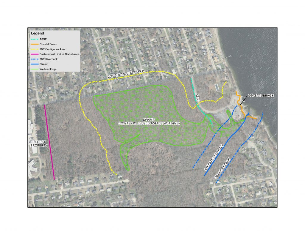
Rhode Island Veteran’s Home in Bristol, RI
Permits from the Rhode Island Department of Environmental Management (RIDEM) and/or the Coastal Resources Management Council (CRMC) can have a significant impact on a project’s design and schedule. To determine which permits were required for the construction of the recently built RI Veterans Home, Pare examined existing aerial photography and GPS-located wetlands. The data was incorporated into a figure to depict the closest wetland resources to the project’s limits of disturbance. These constraint analyses are provided early in the design process to prevent the need for costly design revisions resulting from discovering site constraints in later stages of design.
Our GIS Day celebration ended with a “brain mapping” opportunity to explore how GIS could be used in current or future projects at Pare. To see how we are applying this technology to our own work, please visit the GIS page with representative projects. We will be sharing more information about our GIS projects in the months to come at http://www.parecorp.com/Services/GIS


